MUSEUM OF THE LANDSCAPE, WHERE THE LANDSCAPE BECOMES THE MUSEUM .
LANDeSCAPE INTRODUCTION
CONCEPTUAL MUSEUM GALLERIES OF THE LANDSCAPE
LANDESCAPE (See LandEscape page)HISTORIC FORAGING WALKS
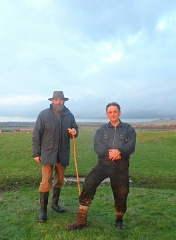
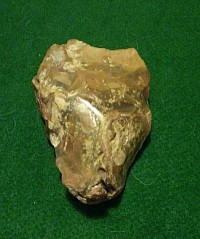
There are several of these Walks during the year which explores various Historic Sites as well as increasing our Forager, Hunter Gathering knowledge of the specific sites this crosses over with the LandEscape project.The LandEscape featured on the left was a group of roughly 20 persons Starting from Raydon Church Suffolk in search of a Barrow marked on an early Ordinance Survey map the Hungry Barrow. This we managed to locate with finds of flint tools identified by our Archeologist on the walk where we ended at the Ancient Church of Shelly with an excellent Oyster Mushroom and Marjoram sandwich cooked on a small stove with Pine Needle and Honey Sauce in the Beautiful Wild flower Churchyard.
The LandEscape was created several years ago after researching various local foraging sites we linked these with a shared interest of Ancient History and linked foraging and lost Ancient sites together.
What we have discovered so far has been quite astounding Today we have the luxury of APPS Google Earth etc where we can look at the landscape from the air and sometimes its possibly to be able to go as far back as WW11 and establish non development areas from the past that may just leave some clue to a Villa , a Hill fort, Ironage Round Houses, Ancient trackways, Curses monuments etc all having links where we can start realising the history of our Landscapes together.
Since LandEscape was started we have discovered many amazing lost and forgotten sites such as an early Iron age Hill Fort circa 500 BC, Medieval pottery kilns circa 12 cent, Ancient Droveways, An Ancient Spring used from Mesolithic times circa 8000 BC , A Roman Soldiers Camp Site 50 AD, just to name a few.
Whilst discovering these sites and the Artifacts discovered we also gather the same Plants that would have been used as Foods, Drinks, Medicinals and general practicle uses such as what Bracket Fungi to use for fire lighting that would have been carried smoldering covered in moss for the day untill you set up camp after a days Foraging, Hunter, Gatherering.
From this knowledge of various periods leaves us to discover fascinating lost worlds that we have all come from and with our knowledge and technologies of today we can experience great journeys through our histories this is what LandEscape works to acheive these experiences bringing us closer to ourselves.
PAST LANDeSCAPE CONCEPTUAL GALLERIES.
GALLERY 1
WALTON ON THE NAZE ESSEX
From Paleolithic Britain 300, 000 to the Romans circa 60 AD.
On this LandEscape the main topics covered is the abundence of Flint tools found here over the years going back to the Paleolithic Clactonian period and much later Neolithic tools approx 5000 yrs ago which some seem to have been washed up on the Beach from the land which joined Britain to the Continent before the flooding approx 6500 BC which is known as Doggerland and has been understood to have been an area of vast hunting grounds etc extending up to today's Scandinavia.
The Food sources of the Naze area today which would have been used for thousands of years for example is the Elder for its Berries, Flowers, Buds and the Branches for making pipes , the young leaves for its Medicinal properties.
Sea Buckthorn Berries for high content of Vitamin C which would have made an excellent drink for winter fevers.
Alexanders which was the first celery introduced by the Romans tasting of Chichory which can be used for sauces , soups and salads, also on the subject of the Romans and the Naze this would have been the place where they would have collected Seplaria the material used in thier cement for Building walls etc such as the one at thier Colonia Victricensis (Colchester)
GALLERY 2
PITCHBURY IRONAGE HILL FORT NORTH ESSEX
Wild-Light was fortunate enough to have this site as a camp in a private woodland for 6 years which held many Food and Drink events which also gave a chance for the visitor to discover a hidden secret that the 50 acre woodland had kept.
This site has its own bubbling fresh water Spring where Mesolithic Stone tools were found which one was identified of coming from a Forager Hunter Gatherer from over 150 miles away in Lincolnshire by the colour of the patina of the Flint.
The Plants foraged here would have been much the same in Mesolithic times circa 8000 yrs ago not much Neolithic Activity or Bronze age then the Iron Age Settlement was built by the Belgea tribes roughly 500 BC in this particular location as it's on a slight hill and has the Colne Valley on one side and the Stour valley on the other but most importantly the hill is covered in springs.
This site was likely to be where Boadicca congregated with her warriors on this ridge 3 miles North of the Roman Capital of modern day Colchester which was raised to the ground in her revolt against the Roman Forces 61AD.
GALLERY 3
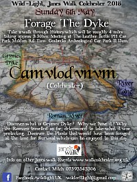
FORAGE THE DYKE UNDERSTANDING CAMULODUNUM (Colchester)
After many discoveries since starting LandEscape it started to emerge the links between these Historic sites for example each of these three galleries mentioned all have links they share together and these have been understood through LandEscape.
For example Pitchbury Hill fort was built as a large five and a half acre double bivallate enclosure to stop any chariot attack built by an early Belgea Iron age Celtic tribe around 500 BC situated between two rivers where hunting grounds in the flood plains were easily accessible providing a good stock of seasonal food.
As the rivers became more important as a resource camps started to move to the flood plain areas creating the the towns and villages that we have dotted along the rivers today.
Imagine then that we see the similar patterns emerging between Rivers.
What we see from the results of the LandEscape Galleries is the movements of our Ancient tribes and the results of locations chosen with simularities for example Pitchbury Hillfort is on a ridge between two rivers and Gosbecks Camulodunum with its defensive Dyke between two Rivers also on a ridge.
I think Pitchbury was part of the early settlements of today's Colchester which moved a couple of miles down the ridge to create settlements of portages next to the river at the Camulodunum Hilly feilds site again on a slight ridge.
It's probable that the Pitchbury ridge was the site of the assembeledge of the thousands of Celt Warriors before the nileation of the Roman British capital.
From this destruction is where we now bring in the signifcance of The LandEscape Gallery 1 Walton on the Naze as after the severe attack on the Roman British capital The Romans had to build a massive defensive wall to avoid any such thing happening again and to do this materials were needed to construct such a defence system which appears to be Seplaria from the Naze at Walton.
CONCLUSION
The conclusion of these three examples of LandEscape Galleries is that we can now understand some of the movements in our local History with walking the land researching , collecting finds and identifying as well as cooking, eating, drinking and discovering practical uses of the plants found on the land.
This is the closest you can get to understanding our Ancestrial past, walking the Landscape in the foot steps, eating the same foods and handling tools and artifacts they have left behind . A
breath taking lifetime experience of how our Landscapes have linkage together.
